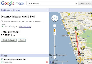
Google’s Distance Calculator Tool, available at Google Maps Labs, helps you calculate the distance between two or more points anywhere on the earth. Since it is a Google Maps Labs feature, you will have to enable it manually. Google Maps Labs provides a testing ground for experimental features that aren’t quite ready for primetime.
How to activate the tool?
* Goto GOOGLE Maps LAB
* Enable Distance Measurement Tool
* Save the changes made.
A small blue scale like image will appear on the left bottom of the Google Map. Click on it to activate it. Now zoom in the map to find out the places. Click to set a starting point and then click on the destination point. You can add more than two points and the tool will add up the distances between all points.
ENJoy...

thanks for the simple tip about how to use maps to measure distance. it’s very simple, but you’d be surprised how frustrated i was getting trying to use some pedometers to to do this.
ReplyDeletedistance measurement